Synopsis:
It all depends on your location today whether you’ll see mainly sunny skies or a period of morning rain. Coastal areas and regions to the East have the best chance of seeing a good amount of sunshine. To the west a band of rain will try and push into Western regions. This is in association with a hung up frontal boundary that will weaken by afternoon. Readings will be several degrees below the average high of 82º with a wind off the Atlantic.
Friday will be a winner with plenty of sun and seasonable readings as high pressure builds into the region.
The first weekend of Summer will be a winner. Abundant sunshine and warm readings are expected as high pressure moves over the region and into the Atlantic. A noticeable increase in humidity will be felt by Sunday.
Scattered showers and storms are likely Monday with a the passage of a cool front.
Stay tuned.
Keep it here for a no hype, no nonsense forecast.
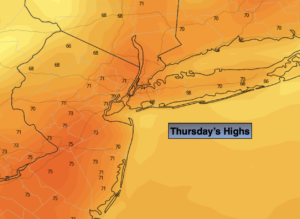
Thursday:
Clouds and sun. Scattered showers (and possibly a period of rain ) West of the City during the morning. Areas to the East and by the coast may see more sun than clouds. Highs in the lower 70s. Southeast to East winds at 5-10mph.
Tonight:
Becoming partly cloudy. Lows in the lower 60s in the City, the 50s inland. Northeast winds less than 5mph.
Friday:
Sunny. Highs in the lower 80s.
Saturday:
Sunny. Highs in the mid 80s.
Sunday:
Mostly sunny, warmer and more humid. Highs in the upper 80s to around 90º.
Monday:
Clouds and sun. Scattered showers and storms. Humid. Highs in the mid to upper 80s.
Catch me on the Fox Weather Stream from 10am-1pm Monday. Find us on Tubi, Roku TV and YouTube TV and as always the Fox Weather App. It’s Free!