Synopsis:
A moist Southerly flow will continue this weekend as a Western Atlantic high gains a bit of dominance in our area. Today will be grey with scattered showers just about anytime. It will be humid. A rumble of thunder can’t be ruled out in the afternoon. Some of the rainfall maybe heavy. Keep in my it will not be a washout today.
Scattered showers will continue into early tonight. Areas of fog will develop.
Sunday will be the drier of the two days. A bulb of warm, humid air will move into the region. Temperatures will be well above average by several degrees on Sunday under a mix of sun and clouds.
Monday will be warm ahead of a cool front. Showers and thunderstorms are expected during the late afternoon and evening.
Slightly cooler readings are expected for Tuesday and Wednesday under a bright sky as high pressure moves in from the Northwest.
Stay tuned.
Keep it here for a no hype, no nonsense forecast.
Saturday:
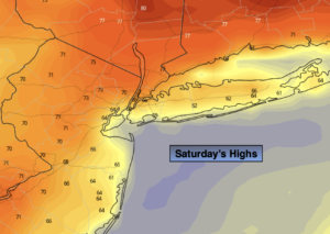
Mostly cloudy and humid. Scattered showers possible just about any time. It will not be a washout. Slight chance of an afternoon isolated thunderstorm with local downpours. Highs in the lower 70s. Southeast winds at 5mph.
Tonight:
Scattered showers early. Areas of fog and drizzle developing. Lows around 60º throughout. Light Southeast to South winds.
Sunday:
Partly sunny. Warmer. Highs in the upper 70s.
Monday:
Sun and clouds. Warm. Afternoon showers and thunderstorms. Highs in the upper 70s.
Tuesday:
Mostly sunny. Highs in the lower to mid 70s.
Wednesday:
Sunny. Highs in the lower 70s.
Catch me on the Fox Business Network from 6am-9am this weekend and on the Fox Weather Stream until Noon. Find us on Tubi, Roku TV and YouTube TV and as always the Fox Weather App. It’s Free!