Synopsis:
Today will feature clouds giving way to partly sunny skies with high pressure nosing in from the Canadian maritimes. It’ll still be cooler than the average high of 68º, but it’ll be pleasant.
Another weak low will move into the region on tonight and Wednesday with another round of showers. If we’re lucky some some may shine during the afternoon.
Skies once again will become partly sunny for Thursday as another high pressure ridge moves overhead. This time around temperatures should be near average or above average!
The next in a series of lows will move toward the East coast on Friday with another round of late day showers. That storm may hang around to our South and East on Saturday keeping the potential for some rain in the forecast. This is not etched in stone.
Stay tuned.
Keep it here for a no hype, no nonsense forecast.
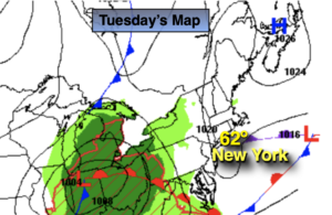
Tuesday:
Clouds to some sun. Highs in the lower to mid 60s. Northeast to East winds at 5-10mph.
Tonight:
Becoming cloudy with showers developing late. Lows around 50º in all areas. Southeast to East winds at 5mph.
Wednesday:
Scattered showers through midday. Some afternoon sun. Highs in the lower to mid 60s.
Thursday:
Mostly sunny. Highs 68º-74º.
Friday:
Mostly cloudy with showers possible during the afternoon. Highs in the lower 60s.
Saturday:
Potential for some rain. Highs in the upper 50s.
Catch me on the Fox Business Network this weekend from 6am-9am and the Fox Weather Stream until Noon. Find us on Tubi, Roku TV and YouTube TV and as always the Fox Weather App. It’s Free!