Synopsis:
The last round of snow will move through the region this afternoon and early evening. An additional inch is possible in the heaviest bands. Travel will become treacherous in areas of snow through sunset.
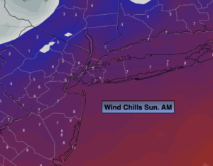
Reading will continue to plummet tonight. Any slush or water will become ice as a deep freeze is expected. Very strong winds will continue with gusts over 50mph likely.
Tonight we Spring Ahead. Don’t forget to move your clock ahead one hour. Eastern Standard Time ends at 2am and Daylight Saving Time resumes. It’s also a good time to change the batteries in your smoke and carbon monoxide detectors.
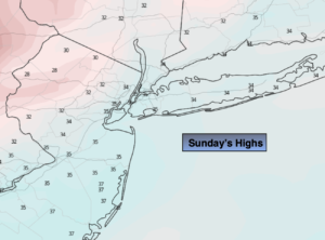
Sunday will be bright, windy and cold readings will at least ten degrees below the average high of 48º. Yes, it’s still Winter. But, lets look on the bright side; we will gain an hour of daylight during the evening!
It’ll be a better feel for the beginning of the week with bright, mild conditions making a visit as high pressure slips off the Southeast coast. Above average readings are expected through Wednesday. There average high temperature is around 50º. Spring officially arrives on March 20th.
Stay tuned.
Keep it here for a no hype, no nonsense forecast.
Tonight:
Early evening areas of snow otherwise clearing, windy and very cold. Lows around 20º in the City, the upper teens inland. Windchills in the single digits. West to Northwest winds at 15-30mph with gusts to 50mph.
Sunday:
Partly sunny, windy and cold. Highs in the mid 30s. West winds at 10-20mph.
Monday:
Mostly sunny. Milder. Highs in the mid 50s.
Tuesday:
Partly sunny. Mild. Highs around 60º.
Wednesday:
Partly sunny. Mild. Highs in the mid to upper 50s.
Thursday:
Partly sunny. Mild. Highs around 60º.