Synopsis:
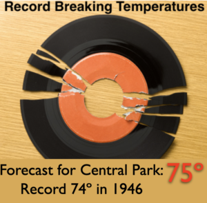
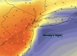
We’ll continue with our Spring preview theme as offshore high pressure continues to pump up a warm wind. Record breaking high temperatures are likely, especially from the City and to the South and West. The record for Central Park is 74º set in 1946. JMW has a forecast high of 75º. Long Island and Connecticut will be much cooler due to a cooler wind off the ocean. A mix of clouds and sun is expected with an increasing Southwest wind. A cool front will approach later in the day, showers and possibly a thundershower is likely at this time.
Showers are likely tonight with the passage of the front.
There will be no Arctic air with this front. Tuesday through Thursday will feature tranquil conditions near or above average. On Wednesday, a weak offshore low may throw clouds our way. Some of the computer models have rain moving in. At this time JMW is keeping it dry, but this may change.
Stay tuned.
Keep it here for a no hype, no nonsense forecast.
Catch me on the Fox Weather Stream/App from 2pm-5pm through Wednesday…
Monday:
Mostly cloudy. Balmy and breezy. Late day showers likely. Highs in the mid 70s. Cooler North and at the coast. Southwest winds increasing to 15-25mph with gusts to 35mph.
Tonight:
Scattered showers and thundershowers. Lows in the lower 40s in the City, the upper 30s inland. West to Northwest winds at 15-30mph with gusts to 40mph. Winds will diminish after midnight.
Tuesday:
Mostly sunny. Mild. Highs around 50º.
Wednesday:
Mostly cloudy. Highs in the mid to upper 40s.
Thursday:
Partly sunny. Highs around 50º.
Friday:
Partly sunny. Highs around 50º.