Synopsis:
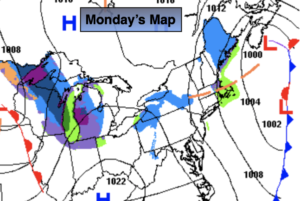
Monday will be blustery and cold behind the intensifying low off the New England coast. Readings will be well below the average high of 49º.
A few flurries are possible on Tuesday with a weak disturbance moving in from the Wes.t
Readings will slowly moderate midweek. High pressure over the Southeast will keep it quiet in our area with a decent amount of sun.
Temperatures will pop on Thursday ahead of a cold front. It’ll be mild. A mix of sun and clouds is expected.
Tranquil conditions for Friday with seasonal readings.
You know where to find a no hype, no nonsense forecast.
Stay tuned.
Monday:
Partly sunny, breezy and cold. Highs in the lower 40s. Northwest winds 15-25mph.
Tonight:
Partly cloudy. Cold. Lows near freezing in the City, the upper teens and 20s elsewhere. West winds 5mph.
Tuesday:
Partly sunny. Flurries possible. Highs in the lower to mid 40s.
Wednesday:
Partly sunny. Highs in the mid to upper 40s.
Thursday:
Partly sunny. Milder. Highs in the mid 50s.
Friday:
Partly sunny. Seasonal. Highs in the upper 40s.