Synopsis:
High pressure will continue to dominate our area through Thanksgiving. The weather will cooperate for the big getaway day on Wednesday. Temperatures will be several degrees below the average high of 52º. Readings will slowly moderate to near average levels by the holiday.
Conditions will change rapidly for shoppers on Friday. A cold front will move through during the morning with scattered showers. The sun will return and the wind increase and become gusty by midday. Highs will once again occur in the morning with readings falling through the 40s during the day.
The weekend will be bright but cold as another Canadian high influencing the region.
I’m keeping an eye on a potential rapidly developing and quick moving storm for the Sunday night timeframe. At this time I’m keeping snow out of the forecast, but stay tuned.
You know where to find a no hype, no nonsense forecast.
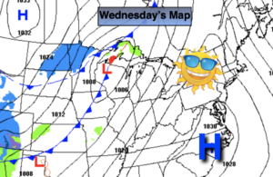
Wednesday:
Sunny and quite cool. Highs in the mid to upper 40s. Northwest to West winds at 5-10mph.
Tonight:
Clear and cold. Lows in the upper 30s in the City, the 20s elsewhere. West winds less than 5mph.
Thanksgiving:
Sunny and pleasant. Highs in the mid 50s.
Friday:
Morning showers giving way to mostly sunny skies. Becoming windy. Highs will occur during the morning and fall into and through the 40s during the day.
Saturday:
Sunny, windy and cold. Highs in the lower 40s.
Sunday:
Sun to clouds. Chilly. Highs in the lower to mid 40s.