Synopsis:
Today will be bright and chilly as high pressure moves in from the Northwest. Readings will be several degrees below the average high of 54º.
Tonight will be cold with scattered frost in urban regions. All other areas have experienced a frost.
Readings will pop almost ten degrees Wednesday and stay warm through Thursday as a Southwesterly wind around high pressure takes hold. In fact, Thursday’s highs will feel more like Spring with temperatures nearly fifteen degrees above average.
A cool front will move through Thursday night with a. period of rain.
November will return on Friday as a chilly airmass moves in.
The weekend looks bright and cool as high pressure dominates.
Stay tuned.
Tuesday:
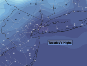
Sunny. Cool. Highs in the upper 40s. West winds at 8-15mph.
Tonight:
Clear. Cold. Lows in the mid to upper 30s in the City, the upper 20s inland. Areas of frost along the urban corridor. West winds diminishing to 5mph.
Wednesday:
Sunny. Milder. Highs in the mid to upper 50s.
Thursday:
Partly sunny. Warm. Highs in the mid 60s.
Friday:
Partly sunny. Colder. Highs in the upper 40s.
Saturday:
Sunny. Chilly. Highs in the upper 40s.