Synopsis:
A large dome of high pressure over the Northern plains will result in a wind from Canada the next several days. The first push of cool air arrived yesterday, a second push of even colder air will arrive tonight. Temperatures today will be a few degrees below the average high of 59º under a mix of clouds and sun.
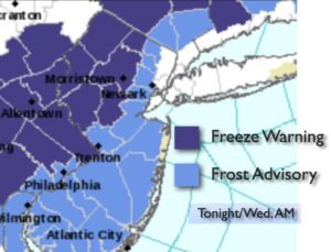
Tonight will be the coldest night of the season so far. Readings inland will be at or below freezing. A Freeze Warning has been posted. Please bring in any potted plants or they will be gone by morning. A Frost Advisory is in effect for many other areas just outside of the urban corridor.
Temperatures will continue to cool down this week and be well below average. A nip in the air for sure. At least it will be rain-free as the big dome of high pressure continues to dominate.
Keep it here for a no hype-no nonsense forecast.
Stay tuned.
Tuesday:
Clouds and sun. Cooler. Highs in the mid 50s. Northwest to West winds at 8-12mph.
Tonight:
Partly cloudy and cold. Lows around 40º in City, near freezing or below inland. Northwest winds at 5-10mph.
Wednesday:
Sunny. Chilly. Highs in the lower 50s.
Thursday:
Partly sunny. Highs in the upper 40s.
Friday:
Partly sunny. Highs in the lower 50s.
Saturday:
Mostly sunny. Highs in the lower 50s.