Synopsis:
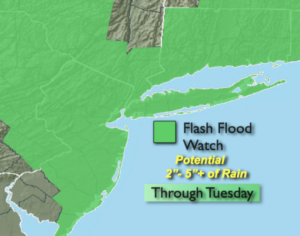
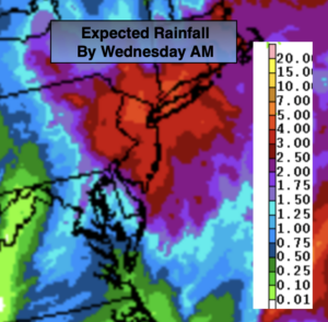
Areas of torrential rain and flooding is possible during the day today as low pressure develops and intensifies Southeast of Long Island. A Flash Flood Watch is in effect through today. Two to five inches of rain is possible. Never drive through flooded roadways, you don’t know how deep that water is- TURN AROUND, DON’T DROWN. The rains intensity will lessen somewhat during the afternoon hours.
Winds will increase later in the day from the Northeast and gust up to 35mph at the coast.
The Nor’easter will spin South of Long Island on tonight into Wednesday morning. The rain won’t be was heavy but the winds will increase and gust up to 50mph over Eastern sections.
The storm will pull farther offshore Wednesday. Morning clouds should give way to some afternoon sun. The winds will continue to be busy.
Thursday we’ll dry out as the sun dominates as high pressure moves in .
The next system will begin to move in from the South on Friday. Early sun will give way to the potential of late day showers. A period of rain is likely Friday night. Saturday will feature mainly cloudy skies with the possibility of scattered showers.
Keep it here for a no hype-no nonsense forecast.
Stay tuned.
Tuesday:
Rain. Heavy at times. Becoming windy later in the day. Highs in the upper 50s. East to Northeast winds at 15-25mph with gusts to 35mph late at the coast.
Tonight:
Periods of rain. Windy. Lows near 50º. North winds at 20-30mph with gusts to 45mph along the coast.
Wednesday:
Clouds giving way to afternoon sun. Windy. Highs around 60º.
Thursday:
Partly sunny. Highs in the lower 60s.
Friday:
Thickening clouds with afternoon showers possible. Highs around 60º.
Saturday:
Mostly cloudy with scattered showers. Highs in the lower 60s.