Synopsis:
Temperatures will sky-rocket to well above average readings today and Thursday. It’ll be ten degrees warmer than yesterday and twelve degrees or so above the average high of 63º. This is all courtesy of high pressure off the Southeast coast and warm air working North. The sun will dominate.
By Friday, a cool front will work through the region uneventful as it’s moisture starved. Temperatures will cool down some.
By the weekend, Canadian air will funnel in as the jet stream rides down from the North. Readings both days will be at or below seasonal averages under a mix of sun and clouds.
Keep it here for a no hype-no nonsense forecast.
Stay tuned.
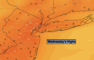
Wednesday:
Mostly sunny. Much warmer. Highs in the mid 70s. West winds at 10-15mph.
Tonight:
Mostly clear. Not as cool as recent nights. Lows in the lower 60s in the City, the 40s and 50s inland. West to Southwest winds at 5mph.
Thursday:
Mostly sunny. Warm. Highs in the mid to upper 70s.
Friday:
Partly sunny. Cooler. Highs in the upper 60s.
Saturday:
Partly sunny. Cooler. Highs in the lower 60s.
Sunday:
Partly sunny. Cool. Highs in the upper 50s.