Synopsis:
The season changer front has moved through. Fall temperatures have finally arrived. High pressure over the South and upper level low pressure over New England will result in a cool flow through the beginning of the week.
Today and Monday skies will be partly sunny. The upper low with disturbances rotating around it will cause isolated afternoon showers both days. Most of the day will be dry.
Temperatures will moderate mid to late week as milder air works around the large area of high pressure to our South.
Keep it here for a no hype-no nonsense forecast.
Stay tuned.
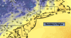
Sunday:
Partly sunny, cooler and breezy (temperatures will actually be average for this time of the year). An isolated afternoon shower is possible. Highs in the mid 60s. West to Northwest winds at 15-25mph.
Tonight:
Clear and chilly. Lows around 50º in the City, the 40s inland. West to Northwest winds at 5-10mph.
Monday:
Partly sunny. Cool. An isolated afternoon shower. Highs around 60º.
Tuesday:
Mostly sunny. Highs in the mid 60s.
Wednesday:
Mostly sunny. Highs in the upper 60s.
Thursday:
Mostly sunny. Mild. Highs in the lower 70s.