Synopsis:
Morning clouds will give way to partly sunny skies. It’ll be mild with readings several degrees above the average high of 66º. High pressure will dominate the Mid-Atlantic states.
We are on a nice run with warm temperatures and bright skies the next several days with high pressure off the coast. By the end of the week it won’t feel like October with readings in some areas approaching 80º!
The next threat of precipitation will be late Saturday as a front approaches. Scattered showers are likely, especially in the afternoon.
It’ll finally feel like Fall on Sunday with readings near the seasonal averages of the mid 60s.
Keep it here for a no hype-no nonsense forecast.
Stay tuned.
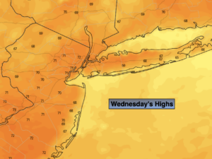
Wednesday:
Clouds to some sun. Highs in the lower 70s. South winds around 5mph.
Tonight:
Partly cloudy. Lows in the lower to mid 60s in the City, the 50s inland. Light winds.
Thursday:
Mostly sunny. Warm. Highs in the mid to upper 70s.
Friday:
Mostly sunny. Warm. Highs in the upper 70s to around 80º.
Saturday:
Clouds and sun. Scattered showers. The best chance is during the afternoon. Warm. Highs in the mid to upper 70s.
Sunday:
Mostly sunny and much cooler (temperatures will actually be average for this time of the year). Highs in the mid 60s.