Synopsis:
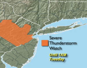
Severe Thunderstorm Watch until 1AM for Warren, Hunterdon, Morris, Middlesex, Somerset and Mercer counties. Severe thunderstorms contain winds in excess of 58mph and or one inch hail. A cool front will push through the region overnight. Isolated thunderstorms are possible, some of which maybe strong to severe.
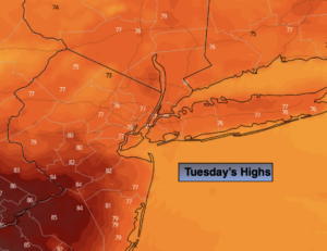
Clouds will give way to sun on Tuesday. A flow off the cooler Atlantic will bring temperatures down to more seasonal levels, the upper 70s.
By Wednesday, another push of warm, humid air will work in under mostly sunny skies.
A cool front will approach Wednesday night and Thursday with scattered showers.
A weak tropical low will be off the coast on Friday. The potential is there for a few showers if the low is close enough. A mix of sun and clouds is expected.
By Saturday the atmosphere will dry out as high pressure builds into the region.
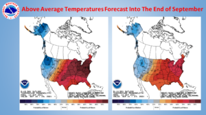
The second map above shows the extended temperature forecast through the end of September. It looks like well above average temperatures can be expected. Summer wants to hang tough!
Stay tuned.
Tonight:
Mostly cloudy. Isolated showers and storms possible. Some of the storms maybe strong to severe. Lows in the 60s throughout. North to Northeast winds at 5-10mph.
Tuesday:
Clouds will give way to partly sunny skies. Cooler. Highs in the upper 70s. Northeast to Southeast winds at 5-10mph.
Wednesday:
Hazy, warm and humid. Highs in the mid 80s.
Thursday:
Clouds, some sun. Scattered showers. Highs around 80º.
Friday:
Clouds, some sun. Spotty showers. Highs in the upper 70s.
Saturday:
Partly sunny. Highs in the lower 80s.