Synopsis:
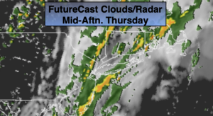
A cool front will stall along the coast today. The forecast has turned more pessimistic. On and off rain is expected. Some of the rain maybe moderate to heavy along and East of the I-95 corridor. In areas of heavy rain please use caution as flooding may occur. Well North and West much of the time could be rain-free. It’ll be much cooler with readings well below the average high of 80º.
Skies will become mostly clear overnight as the system continues to push offshore.
Friday through the weekend look fantastic as high pressure moves across the region. Mainly sunny skies and near seasonal temperatures are expected Friday and Saturday. By Sunday, the high will move off the coast and a Southwesterly flow will develop. This will result in warmer and more humid conditions.
Stay tuned.
Today:
Mostly cloudy with on and off rain. Cooler. Highs in the mid 70s. North wind at 5-10mph.
Tonight:
Becoming mostly clear. Lows in the lower 60s in the City, the 50s inland. Northwest wind at 5mph.
Friday:
Mostly sunny. Highs in the mid to upper 70s.
Saturday :
Sunny. Highs in the upper 70s.
Sunday:
Mostly sunny. Warmer and more humid. Highs in the lower to mid 80s.
Monday:
Mostly sunny. Warm and humid. Highs in the lower to mid 80s.