Synopsis:
Today will feature clouds and some sun. It’ll be warm but you’ll notice the humidity will be lower. This is due to a Northwest wind.
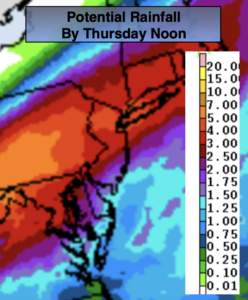
The remnants of Ida will affect our region beginning Wednesday with on and off showers. Steadier and heavier rain is likely toward evening. It’ll be much cooler with a light wind out of the Northeast. Rain is expected into Thursday morning. Our region will not damaging winds, but an axis of heavier rain will set up as the remnants moves up the Appalachians and into the tri-state areas. Exactly where the heaviest rain will fall will be determined as we get closer to the event. Needless to say, we do not need anymore rain. The grounds are saturated and rivers and streams remain high. The potential for flooding exists. A Flash Flood Watch is in effect for the entire region for 2″-5″+ of rain. The potential rainfall map is above.
Friday will be a September gem as cooler high pressure influences the region. Abundant sunshine is expected with low humidity.
A peek into the Labor Weekend will make most smile! High pressure will dominate resulting in mainly sunny skies and comfortable readings.
Keep it here for a no nonsense, no hype forecast.
Stay tuned.
Today:
Clouds, some sun. Warm and less humid. Highs in the mid 80s. Northwest winds at 5-10mph.
Tonight:
Mostly cloudy. Lows around 70º in urban areas, the 60s inland. Northwest winds at 5mph.
Wednesday:
Mostly cloudy with on and off showers. Steadier and heavier rain likely toward evening. Much cooler. Highs in the lower to mid 70s.
Thursday:
Rain ,possibly torrential in the morning. Becoming partly sunny. Highs in the mid 70s.
Friday:
Sunny. Highs in the mid to upper 70s.
Saturday:
Sunny. Highs in the mid to upper 70s.