Synopsis:
The heat and humidity will return for the rest of the week as a bubble of hot air develops around a Western Atlantic high pressure system.
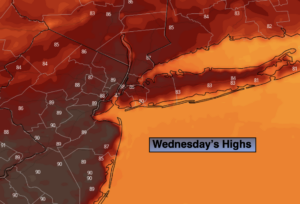
Any morning clouds and fog will give way to hazy skies today. Readings will get a few degrees above the average high of the mid 80s. An isolated late day storm is possible. Most areas will remain storm-free.
Thursday and Friday will be hot with mainly sunny skies. The humidity will be high.
Saturday will be sizzlin’ with scattered afternoon storms with an approaching cool front.
The front looks to stall in the vicinity on Sunday resulting in scattered showers and storms.
Stay tuned.
Keep it here for a no nonsense, no hype forecast.
Wednesday:
Any morning clouds and fog will give way to hazy sun. It’ll be very warm and humid. Highs in the upper 80s. Winds becoming Southwest at 5-10mph.
Tonight:
Partly cloudy. Muggy. Lows in the mid 70s in the City, the mid 60s inland. West winds less than 5mph.
Thursday:
Hazy, hot and humid. Highs in the lower 90s.
Friday:
Hazy, hot and humid. Highs in the lower to mid 90s.
Saturday:
Hazy, hot and humid. Scattered afternoon storms. Highs in the lower 90s.
Sunday:
Mostly cloudy, warm and humid. Scattered showers and storms. Highs in the mid 80s.