Synopsis:
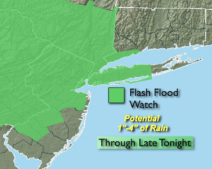
A cool front will slowly push South overnight. Unfortunately, the threat of torrential rains exists for much of the tri-state area through the night. The front will remain over the region and thunderstorms are forecast to train over the same areas. The ground is completely saturated. Locally up to three inches of rain is possible in the tropical airmass. A Flash Flood Watch is up for much of the region through late tonight. Never drive through a flooded roadway; you can’t judge how deep the water is. TURN AROUND, DON’T DROWN.
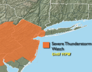
In addition, scattered severe thunderstorms are possible. A Severe Thunderstorm Watch is until 11pm for most of New Jersey and New York City. Any of the storms have the capability of producing winds in excess of 58mph. Torrential rain and frequent cloud to ground lightning will accompany the storms.
A cooler flow off the Atlantic will be with us for Tuesday. A mix of clouds and sun is expected. Readings will be several degrees below the average high of the mid 80s.
The heat will return for the mid to late week period as a bubble of hot air develops around a Western Atlantic high pressure system. Hazy skies are expected with isolated afternoon storms possible on Wednesday. Thursday and Friday will be hot and humid and mainly storm-free.
Saturday will be sizzlin’ with scattered afternoon storms with an approaching cool front.
Stay tuned.
Keep it here for a no nonsense, no hype forecast.
Tonight:
Showers and thunderstorms. Areas of torrential rain. Lows in the upper 69s in the City, the mid 60s inland. East to Northeast winds at 5mph.
Tuesday:
Clouds and sun. Not as warm, moderately humid. Highs around 80º. Cooler at the coast. East winds at 5-10mph.
Wednesday:
Hazy, very warm and humid with spotty afternoon storms. Highs in the upper 80s.
Thursday:
Hazy, hot and humid. Highs around 90º.
Friday:
Hazy, hot and humid. Highs in the lower 90s.
Saturday:
Hazy, hot and humid. Scattered afternoon storms. Highs in the lower 90s.