Synopsis:
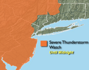
*** Severe Thunderstorm Watch for most of NJ and areas well North of the City until Midnight. Thunderstorms that do develop, have the potential, within the Watch area, to produce winds in excess of 58mph and or one inch hail***
A cool front will approach the region this evening with scattered storms. Some of the storms maybe strong to isolated severe. The second half of the night will be more tranquil with the activity ending.
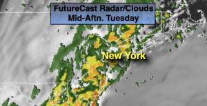
Relief from the heat and humidity will arrive on Tuesday. Much cooler readings are expected. Temperatures will be several degrees below the average high of the lower 80s. Humidity levels will also be much lower. The front will have moisture riding up along it. Scattered showers are in the forecast mainly from late morning through late afternoon. Temperatures will fall into and through the 60s during the afternoon.
High pressure over the Ohio Valley will move off the Northeast coast through late week. This will keep the heat and humidity at bay. Some nice conditions to say the least for early Summer.
By Saturday, the humidity will be back along with hazy sun.
Stay tuned.
Keep it here for a no nonsense, no hype forecast.
Tonight:
Scattered showers and storms early tonight. Partly cloudy late. Lows in the 60s throughout. South winds becoming West at 5mph.
Tuesday:
Mostly cloudy with scattered showers. Much cooler and less humid. Highs in the lower to mid 70s early with temperatures falling through the 60s during the afternoon. Northwest winds at 10-15mph.
Wednesday:
Sunny. Comfortable. Highs in the mid 70s.
Thursday:
Sunny. Highs near 80º.
Friday:
Partly sunny. Highs around 80º.
Saturday:
Hazy sun, more humid. Highs in the mid 80s.