Synopsis:
Weather systems will continue to remain weak over the Northeast through Monday. Today will be a brighter day with near seasonal readings. A decent second half of the weekend.
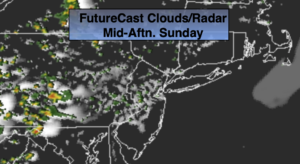
Scattered showers are in the forecast for late tonight and Monday with a disturbance moving through. Readings will be a few degrees below the average high of the upper 70s.
Tuesday into the midweek period will feature high pressure building in from the West. This will result in mainly sunny skies and warm readings.
Stay tuned.
Keep it here for a no nonsense, no hype forecast.
Today:
Sun and clouds. Highs in the mid to upper 70s. Southwest to South winds at 5-10mph.
Tonight:
Becoming mostly cloudy with showers after midnight. Lows in the lower 60s in the City. The upper 50s to around 60º inland. South winds at 5mph.
Monday:
Mostly cloudy with scattered showers. Highs in the mid 70s.
Tuesday:
Partly sunny. An isolated shower possible. Warmer. Highs around 80º.
Wednesday:
Sunny. Highs around 80º.
Thursday:
Sunny. Highs around 80º.