Synopsis:
High pressure to our South will continue to bring up the temperatures through today. In fact, it will be the warmest day of the year so far. Readings will be July like, at least fifteen degrees above the average high of the lower 70s. Abundant sunshine is expected. Please slather on the sunscreen. The UV forecast for the first time this year is a very 8 on a scale of 1-12.
High pressure East of New England will push a back door cold front through much of the area tonight. This change in airmass will not be accompanied by any showers. The result though will be much cooler days for most of the region Thursday and Friday. Temperatures will still be at or just above seasonal levels. Well to the east readings will be below average due to the influence of an ocean breeze off the chilly Atlantic. Well to the West readings will be the warmest. The push of cool air will stall over Western sections. A mix of sun and clouds is expected both days.
By the weekend, the cool front will washout and the warmer air just to our West will once again return. Saturday and Sunday will feature a mix of sun and clouds. Sunday will be quite warm with the Summer feel retuning.
Keep it here for a no nonsense, no hype forecast.
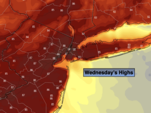
Wednesday:
Sunny. Very warm. Highs in the mid to upper 80s. Northwest winds at 5-10mph.
Tonight:
Clear and mild. Lows in the lower 60s in the City, the 50s inland. Southeast to East winds less than 5mph.
Thursday:
Mostly sunny. Much cooler. Highs in the mid 70s in the City. Cooler to the East, warmer to the West.
Friday:
Partly sunny. Highs in the mid 70s. Cooler over Eastern areas, warmer over Western areas.
Saturday:
Sun & Clouds. Warmer. Highs around 80º.
Sunday:
Sun & Clouds. Warm. Highs in the mid 80s.