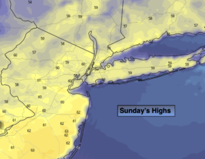
Synopsis:
Weather systems are weak along the East Coast. So, basically what you see is what you get. Today readings will be around the normal high for the date which is in the lower 60s. A mix of sun and clouds are expected.
Temperatures will warm early next week to above average levels. A spot shower is possible Monday afternoon. Tuesday will be the best day of the bunch as weak high pressure remains in control. It will be warm!
On Wednesday, a cool front will approach. Showers are likely, especially in the afternoon. It’ll still be mild.
Thursday will be breezy and cooler behind the front under a mix of sun and clouds.
Stay tuned.
Keep it here for a no nonsense, no hype forecast.
Today:
Partly sunny. Seasonal. Highs around 60º. Northwest to West winds at 5-10mph.
Tonight:
Partly cloudy. Lows around 50º in the City, the upper 30s and 40s inland. West winds under 5mph.
Monday:
Partly sunny. Spot PM shower chance. Highs in the mid 60s.
Tuesday :
Partly sunny. Warmer. Highs in the lower 70s.
Wednesday:
Clouds, some sun. Showers are likely, especially in the afternoon. Highs in the mid 60s.
Thursday:
Partly sunny, breezy and cooler. Highs in the mid 50s.