Synopsis:
It will be more tolerable today as the cold core airmass loses it’s grip on the region. Abundant sunshine is expected with readings getting closer to the average high which is in the mid 50s (we’ll probably fall short by a few degrees).
Clouds increase tonight as a weak upper level disturbance moves through.
It may start off a bit grey for Easter but the sun will win the battle. High pressure to our South will be responsible for our decent conditions. Readings will be near seasonal averages on Sunday.
Looking ahead, early to mid week next week will be bright and mild as high pressure remains in control.
Have a safe and Happy Easter!
Keep it here for a no nonsense, no hype forecast.
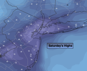
Today:
Mostly sunny. More tolerable. Highs in the lower 50s. Northwest winds at 8-12mph.
Tonight:
Mostly cloudy. Not as cold as last night. Lows around 40º in the City, near 30º well inland to the 30s in the nearby ‘burbs. Light winds.
Easter Sunday:
Clouds to sun. Seasonal. Highs in the mid to upper 50s.
Monday:
Mostly sunny. Milder. Highs in the lower 60s.
Tuesday:
Partly sunny. Highs in the lower 60s.
Wednesday:
Partly sunny. Highs in the lower 60s.