Synopsis:
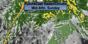
On and off rain is expected for today, meaning there will be dry times. Some of the rain will be briefly heavy in spots. It’ll be mild and winds will become gusty during the afternoon. We’ll have to keep our eye on a possible squall line during the evening with an approaching cold front. The best chance of seeing some rough conditions will be over central and Southern NJ.
The rain will end this evening as the front pulls offshore. Winds will dramatically increase out of the West and gust up to 50mph.
Monday and Tuesday will be dry with near to above average readings as high pressure dominates.
As we turn the calendar from March to April a storm will affect the region. On Wednesday any morning sun will give way to a wet afternoon. Readings will be a few degrees above the average high of the mid 50s. April’s debut on Thursday will start off wet. The low will pull up and off the coast during the day bringing an end to the rain. Some afternoon sun is possible. Colder air will work in. The mercury will drop about ten degrees below average for the high.
Keep it here for a no nonsense, no hype forecast.
Today:
On and off rain. Dry times. The rain could come down briefly heavy at times. Becoming windy. Highs in the lower 60s. East to South winds increasing to 15-25mph with gusts to 35mph late.
Tonight:
Evening scattered thunderstorms with high winds, otherwise becoming partly cloudy and remaining windy. Lows in the 40s throughout. West winds at 15-30mph with gusts to 50mph.
Monday:
Partly sunny windy and seasonal. Highs in the mid 50s.
Tuesday:
Sunny. Highs in the upper 50s.
Wednesday:
Morning sun. Afternoon rain. Highs in the lower 60s.
Thursday:
Morning rain. Afternoon sun. Highs in the mid to upper 40s.