Synopsis:
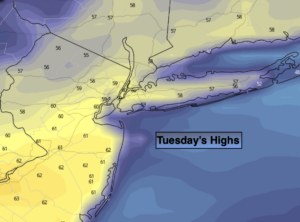
High pressure will dominate our weather through the week. The high will move along the coast and then move off the coast. This will result in a Southerly then Southwesterly wind component. Temperatures pop today-many regions will top 60º! A Spring Preview will be with us through the end of the week. Don’t expect much change in sky conditions through Thursday. The sun will dominate.
The next chance of showers won’t come until Friday afternoon with an approaching cold front.
The weekend will be cooler but bright with high pressure influencing our weather from Canada.
Stay Tuned.
Keep it here for a no nonsense, no hype forecast.
Today:
Sunny. Much warmer. Highs around 60º. Southwest to Northwest winds at 5-10mph.
Tonight:
Mostly clear. Lows around 40º along the coast, the 20s and 30s inland. Northwest to Northeast winds at 5mph.
Wednesday:
Sunny. Mild. Highs in the mid to upper 50s.
Thursday:
Mostly sunny. April-like. Highs in the mid to upper 60s.
Friday:
Sun and clouds. Warm. Chance of afternoon showers. Highs in the mid 60s.
Saturday:
Partly sunny. Cooler. Highs around 50º.