Synopsis:
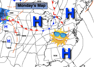
High pressure will dominate our weather through the week. High pressure usually means quiet weather. Don’t expect much change in sky conditions through Thursday. The sun will dominate.
Today we’ll start the upward trend in temperature. The average high is in the mid 40s. Readings will be just shy of average.
Clouds will roll in tonight with an upper level disturbance rapidly moving through. Readings will remain above freezing in most areas. The exception being well inland.
The high will re-establish itself along and then off the East coast for the majority of the week. This will result in a Southerly then Southwesterly wind component. Temperatures pop on Tuesday and reach April-like readings mid to late week- a Spring preview. Yep, the 60s are in our future!
The next chance of showers won’t come until Friday afternoon with an approaching cold front.
Stay Tuned.
Keep it here for a no nonsense, no hype forecast.
Today:
Sunny. Highs in the lower 40s. Northwest to West winds at 5-10mph.
Tonight:
Mostly cloudy. Not as cold as recent nights. Lows in the mid 30s along the coast, the 20s inland. Southwest winds at 5mph.
Tuesday:
Sunny. Much warmer. Highs around 60º.
Wednesday:
Sunny. Highs in the 50s to around 60º.
Thursday:
Mostly sunny. April-like. Highs in the mid 60s.
Friday:
Partly sunny. Warm. Chance of afternoon showers. Highs in the mid 60s.