Synopsis:
High pressure will dominate our weather through next Thursday. High pressure usually means quiet weather. Don’t expect much change in the sky conditions from now into much of next week. Sunny skies will dominate.
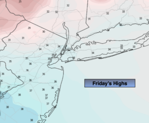
Now, the beginning of the period we’ll experience below average temperatures. The average high is 45º. The reason is due to the high originating in Canada. Today will be cold, despite the bright skies. Highs will be just above freezing. Winds will be gusty adding to the chill.
Tonight readings once again will be well below freezing. At least the wind will diminish some.
There will be a nip in the air thorough the weekend under mainly sunny skies.
The high will re-establish itself along and then off the East coast for the majority of next week. This will result in a Southerly wind component. Temperatures will climb and get well above average by midweek- a Spring preview.
There are no major storms of concern in the near future and in fact, it will be precipitation free until further notice.
Stay Tuned.
Keep it here for a no nonsense, no hype forecast.
Today:
Mostly sunny. Cold. Highs in the mid 30s. Northwest winds at 15-25mph with gusts to 30mph.
Tonight:
Clear and cold. Lows in the upper 20s along the coast, the upper teens and 20s inland. Northwest winds diminishing to 8-12mph.
Saturday:
Mostly sunny. Chilly. Highs in the upper 30s.
Sunday:
Sunny. Highs around 40º.
Monday:
Sunny. Seasonal. Highs in the mid 40s.
Tuesday:
Sunny. Much warmer. Highs in the mid to upper 50s.