Synopsis:
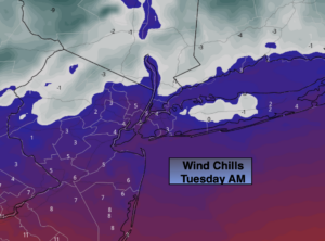
A brief visiting Arctic airmass will be with us today. Wind chills this morning will be in the single digits to near 0º. Definitely a slap in the face while heading outdoors. Readings will be get just above freezing for highs under sunny skies. Winds will diminish during the afternoon.
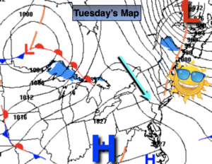
We are in for a rollercoaster ride in temperature. Wednesday will be much milder under mainly sunny skies as high pressure moves overhead. Readings will flirt with 50º (a far cry from 0º windchills 24 hours earlier). Temperatures will return to seasonal levels by Thursday as cooler air works in from the North.
By Friday, another shot of Canadian air will chill the tri-state area with readings remaining in the upper 30s.
The weekend looks tranquil and chilly as high pressure continues to dominate the Mid-Atlantic and Northeast.
There a no major storms of concern in the near future.
Stay Tuned.
Keep it here for a no nonsense, no hype forecast.
Today:
Mostly sunny and much colder. Windy in the morning. Highs in the mid 30s. Northwest winds at 15-30mph with gusts to 45mph in the morning. Winds will diminish during the day.
Tonight:
Clear and cold. Lows in the lower 30s along the coast, the 20s inland. West winds at 5-10mph.
Wednesday:
Sunny, milder. Highs near 50º.
Thursday:
Sunny. Seasonal. Highs in the mid 40s.
Friday:
Partly sunny. Colder. Highs in the upper 30s.
Saturday:
Mostly sunny. Chilly. Highs in the lower 40s.