Synopsis:
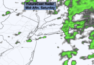
It will be a damp start to the day. Showers are likely as a weak impulse moves our way from the South. It will be mild. By afternoon most of the showers will have pulled East leaving the area mainly rain-free.
Skies will become partly cloudy tonight as we’ll be in between systems. Readings will remain above freezing with the exception of areas well inland.
February’s finale on Sunday will start off with a few peeks of sun, otherwise clouds will thicken as another impulse rides along a frontal boundary to our South. This will result in showers during the afternoon. Readings will be near the average high of the mid 40s.
March will come in like a lamb on Monday. Any morning showers will give way to partly sunny skies. It will be mild.
Colder sun will greet us Tuesday as a short-lived Arctic blast visits the region. Readings will be just above freezing for highs and a gusty wind will add a bite.
Wednesday will be more tolerable under mainly sunny skies as high pressure moves overhead.
Stay Tuned.
Keep it here for a no nonsense, no hype forecast.
Today:
Cloudy with scattered showers. Mild. The mid to late afternoon will be mainly rain-free. Highs in the lower 50s. Southeast to West winds at 5mph.
Tonight:
Becoming partly cloudy. Lows in the upper 30s along the coast, the upper 2s to around freezing in the distant ‘burbs. Northwest to North winds at 5mph.
Sunday:
A few glimpses of morning sun, otherwise thickening clouds. Showers are likely by afternoon. Highs in the mid 40s.
Monday:
Early morning showers to sun. Highs in the upper 40s.
Tuesday:
Mostly sunny, windy and much colder. Highs in the mid 30s.
Wednesday:
Sunny, milder. Highs in the upper 40s.