Synopsis:
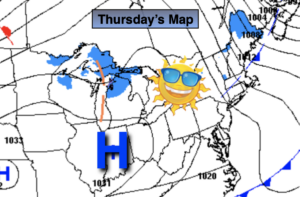
Today and Friday will feature abundant sunshine with just above average readings as high pressure moves in from the West. The average high is in the mid 40s.
Clear, calm and cold conditions tonight. Most regions will be at or below freezing.
The next chance of precipitation is Saturday. Showers are likely as a Southerly wind keeps us mild.
February’s finale on Sunday looks more dreary as another impulse will now ride along a frontal boundary to our South. This will result in mostly cloudy skies with showers possible during the afternoon. Hey, its not snow-no complaints!
March will come in like a lamb on Monday. Under partly sunny skies readings will reach the mid to upper 40s.
Stay Tuned.
Keep it here for a no nonsense, no hype forecast.
Today:
Mostly sunny, breezy and mild. Highs in the mid 40s. Northwest winds at 10-20mph.
Tonight:
Clear and cold with diminishing winds. Lows near freezing along the urban corridor, the mid to upper 20s inland. Northwest winds at 5mph.
Friday:
Sunny. Highs in the mid 40s.
Saturday:
Mostly cloudy. Scattered showers. Highs around 50º.
Sunday:
Mostly cloudy. Showers likely by afternoon. Highs around 50º.
Monday:
Partly sunny. Highs in the mid to upper 40s.