Synopsis:
Milder conditions and sunshine will return today-well deserved to say the least. Highs will be around 40º as weak high pressure takes hold.
Clouds will increase and thicken tonight ahead of the next system moving in from the West.
A bit of light snow or a mix is expected inland tomorrow (there could be a coating North and West). Along the coast it’ll be mild enough for rain as low pressure moves through the Ohio Valley into New England.
Looking ahead; it will get colder this weekend. Both days will feature a mix of sun and clouds. Low pressure on Sunday will slide off the Carolina coast and well out to sea, not influencing our weather.
A modified Arctic blast will arrive for the beginning of next week.
Stay Tuned.
Keep it here for a nonsense, no hype forecast.
Today:
Partly sunny. Milder . Highs around 40º. Northwest winds at 5-10mph.
Tonight:
Increasing and thickening clouds. Lows in the mid 30s in the City, the upper 20s inland. Light and variable winds.
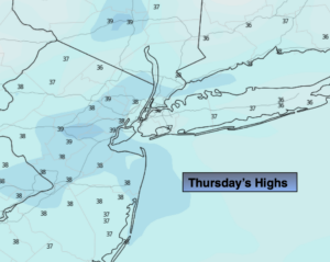
Friday:
Light snow or a mix North and West. Light rain along the coast. Highs in the lower 40s, 30s inland.
Saturday:
Partly sunny. Colder.. Highs in the mid to upper 30s.
Sunday:
Partly sunny. Highs in the mid to upper 30s.
Monday:
Mostly sunny.Colder. Highs around 30º.