Synopsis:
A major snowstorm will affect much of the region Today into Tuesday. The computer models continue agreement that a storm will intensify off the Delaware and NJ coast today and only slowly drift up and off our coastline through Tuesday. This is a classic track for a snowstorm in the metropolitan area. The sharp cutoff of the accumulating snow continues to be over Eastern Long Island and coastal NJ. A mix will occur here, even plain rain for a time over Southern NJ. Elsewhere heavy snow is expected.
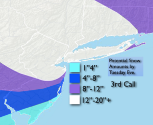
Winter Storm Warnings are up now for the entire tri-state area. The “3rd Call” possible snow amounts have been posted above. A foot of snow and then some is likely for a majority of the region. Some areas may receive 20″+. The possible snow amounts will be fine tuned throughout the storm.
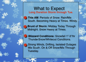
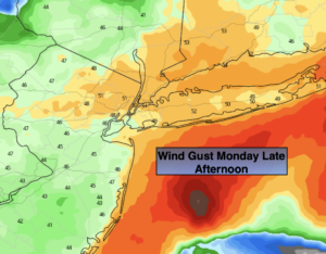
The storm will likely be of long duration -over 36 hours , continuing on and off through Tuesday. The brunt of the storm will be this afternoon and into early tonight. Winds will gusts over 50mph at the coast. Blizzard conditions can be expected during this time. Snowfall rates of 1″-3″/hr are likely. Visibility will be reduced to near zero (whiteout conditions) at times and thunder snow is possible. Coastal flooding will also occur at times of high tide.
The storm will pull away from the East coast Wednesday. The sun will return and it will be time to dig out.
Stay Tuned.
Keep it here for a nonsense, no hype forecast.
Today:
Periods of Snow. Heavy at times. Mix/rain South changing back to snow later in the day. Windy. Highs within a few degrees of freezing. Northeast winds at 20-40mph with gusts to 55mph at the coast.
Tonight:
Periods of snow. Mix to the East. Lows around 30º the City, the 20s inland. Northeast/Northeast winds at 20-40mph and diminishing late.
Tuesday:
On and off snow. A mix possible at the coast. Windy. Highs around freezing.
Wednesday:
Partly sunny. Windy. Highs in the mid 30s.
Thursday:
Mostly sunny. Seasonal . Highs in the upper 30s.
Friday:
Mostly cloudy. Chance of showers. Milder. Highs in the lower 40s.