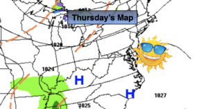
Synopsis:
The sun will dominate today with seasonal readings as high pressure over the Southeast dominates.
Tonight will be partly cloudy and not as cold in urban areas. Inland readings will be below freezing.
On Friday, moisture will begin to build in from the South. This will increase our clouds. Showers will develop during the afternoon.
Low pressure will develop over the Southern Appalachians on Saturday morning and intensify as it moves up the Piedmont and off the Maryland coast during the afternoon. Rain is expected. The European and GFS model are robust in the storm’s strength. This would provide enough cold air to mix down and create a rain to wet snow mix scenario North and West, especially over the higher elevations. This is a low potential right now (any accumulation prediction, if any at all would be ridiculous). The NAM model is more offshore in it’s solution resulting in a sharp cutoff between the heavy rain swath at the coast and lighter rain North and West. No matter the strength of the storm most of Saturday will be wet. The storm may pull away far enough to the North and East to allow the rain to taper off during the afternoon.
Sunday will be the better half of the weekend as the sun returns. Readings will be below average both days.
Stay Tuned.
Keep it here for a no nonsense, no hype forecast.
Today:
Seasonal sun. Highs in the upper 40s. West to Southwest winds at 5-10mph.
Tonight:
Partly cloudy. Lows in the lower 40s in urban areas, the 20s and 30s inland. Southwest winds diminishing to 5mph.
Friday:
Increasing clouds. Afternoon showers likely. Highs around 50º.
Saturday:
Rain likely. Low potential of a some wet snow inland. Rain tapering off during the afternoon. High in the 40s.
Sunday:
Partly sunny, breezy and chilly. High in the lower to mid 40s.
Monday:
Partly sunny. High in the lower to mid 40s.