Synopsis:
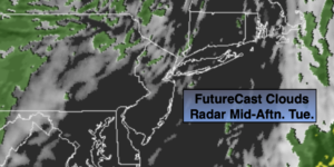
December’s debut will be cooler with any sun giving way to mostly cloudy skies. Spotty showers are possible as a potent upper level low moves through the Northeast. It’ll be breezy with readings still a few degrees above the average high of 49º.
Tonight will be colder than recent nights under partly cloudy skies.
Tranquil conditions are expected through midweek along with a cool down under the influence of high pressure. The sun will dominate.
A mix of sun and clouds is expected for Friday and Saturday. The forecast is one of low confidence as some of the computer models develop a storm to our South and move it North into our region during Saturday. This will be fine tuned later today. Temperatures will be near seasonal levels for early December.
Stay Tuned.
Keep it here for a no nonsense, no hype forecast.
Today:
More clouds than sun. Spotty showers are possible. Breezy. Highs in the lower to mid 50s. West to Southwest winds at 15-25mph.
Tonight:
Partly cloudy. Colder. Lows around 35º in the City, around 30º inland. West to Southwest winds at 5-10mph.
Wednesday:
Partly sunny and chilly. Highs in the mid 40s.
Thursday:
Seasonal sun. Highs in the upper 40s.
Friday:
Sun and clouds. Spot shower possible late. Highs around 50º.
Saturday:
Partly sunny. Highs in the upper 40s.