Synopsis:
Friday will feature abundant sunshine and warm readings as high pressure off the coast gives us a late Summer-like day.
A weak disturbance riding to our South will result in more clouds than sun on Saturday. Spotty showers can’t be ruled out, but much of the day will be dry. Sunday will be the better half of the weekend and it will be warmer under a mix of sun and clouds.
The beginning of next week will be mild. A deep Southerly flow will develop. This will increase our humidity and also increase our cloud cover. A spot shower is possible Monday under a mix of sun and clouds. A better chance of showers comes our way for Tuesday as a cold front approaches.
Stay Tuned.
Keep it here for a no nonsense, no hype forecast..
Tonight:
Mostly cloudy. Lows in the mid 60s in urban areas, the 50s inland. Southwest wind less than 5mph.
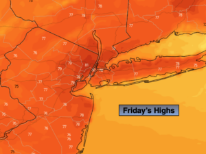
Friday:
Mostly sunny. Warm. Highs around 80º.
Saturday:
More clouds than sun. Spotty showers possible. Highs in the mid 70s.
Sunday:
Partly sunny. Warm. Highs near 80º.
Monday:
Sun and clouds. Spotty showers possible. Highs in the mid to upper 70s.
Tuesday:
More clouds than sun. Scattered showers. Highs in the mid 70s.