
Synopsis:
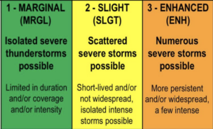
Today will be hazy, warm and humid. The majority of the day will be dry. Scattered thunderstorms are possible toward evening in the unstable airmass. Some of the storms maybe strong to severe. Severe thunderstorms contain winds in excess of 58mph and or one inch hail. The greatest threat of severe weather looks to be South of the City for this evening (map above).
Scattered early storms tonight, otherwise becoming partly cloudy.
A cool front will move through the region Friday. The front is lacking moisture and will come through precipitation free. The sun will dominate and humidity levels will come down under abundant sunshine.
The Labor Day Weekend is looking like a winner! Strong high pressure will move in from the West and through the region during the three days. Skies will be mainly sunny. It will be comfortable with readings near average and low levels of humidity. It will be a trifecta of beauties. Enjoy!
Stay Tuned.
Keep it here for a no nonsense, no hype forecast.
Today:
Sun and clouds. Warm and humid. Late day and evening scattered storms. Highs in the mid 80s. Northwest to Southwest winds at 5-10mph.
Tonight:
Scattered storms early tonight, otherwise becoming partly cloudy. Lows in the lower 70s in the City, the 60s inland. Southwest to Northwest wind at 5mph.
Friday:
Mostly sunny with lowering humidity. Warm. Highs in the mid 80s.
Saturday:
Sunny. Highs in the upper 70s.
Sunday:
Sunny. Highs around 80º.
Labor Day:
Mostly sunny. Highs in the lower 80s.