Synopsis:
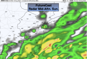
Today will be grey with areas of rain and showers as low pressure moves up and off the coast. It’ll be much cooler with the clouds and rain-cooled air. Readings will be at least ten degrees below the average high of 83º. The latest computer guidance (map above) suggests the rain will taper off over Northwestern areas during the afternoon. The coast will most likely pickup the highest totals.
Showers will end along the coast this evening. Skies will remain mostly cloudy overnight with areas of patchy fog.
Increasing sunshine is expected for the beginning of the week. A spot storm is possible Monday afternoon. The rest of the week will be bright and warm as high pressure works in from the West and moves over the region. It will be comfortably warm and humidity levels will be in check. Some delightful mid-August weather!
Stay Tuned.
Keep it here for a no nonsense, no hype forecast.
Today:
Cloudy with areas of rain. Much cooler. Highs in the lower 70s. Northeast winds at 5-10mph with gusts to 20mph along the coast.
Tonight:
Evening coastal showers, otherwise mostly cloudy with patchy fog. Lows in the 60s throughout. Northeast winds at 5-10mph.
Monday:
Partly sunny. Spotty PM storm. Highs around 80º.
Tuesday:
Partly sunny. Warm. Highs in the mid 80s.
Wednesday:
Mostly sunny. Highs in the mid 80s.
Thursday:
Mostly sunny. Highs in the mid 80s.