Synopsis:
A typical Summer pattern will be with us for sometime. Weather systems are weak and the country has heated up. Today will be mainly sunny and hot. The threat of afternoon and evening storms is very low. Friday will be hot and humid. A weak front will work down from New England. This will spark scattered storms later in the afternoon and at night.
The weather will cooperate for the 4 of July Weekend. It’ll be sunny and warm as weak high pressure develops off the Northeast coast. The humidity will be more tolerable Saturday and may inch up a tad by Sunday. Enjoy!
Stay Tuned.
Keep it here for a no nonsense, no hype forecast.
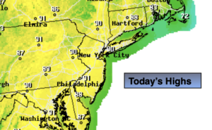
Today:
Mostly sunny and hot. Highs around 90º. Northwest winds at 5-10mph.
Tonight:
Partly cloudy. Warmer than recent night. Muggy. Lows in the mid 70s in the City, the upper 60s and lower 70s inland. Northwest winds less 5mph.
Friday:
Hazy, hot and humid. Scattered PM Storms. Highs around 90º.
4th of July:
Mostly sunny. Not as hot or humid. Highs in the lower 80s.
Sunday:
Mostly sunny. Highs in the mid 80s.
Monday:
Partly sunny. Hot. Highs around 90º.