Synopsis:
A cool front will be approaching this evening. It will feel like the tropics with high humidity. Scattered showers and spotty storms are possible. Isolated severe thunderstorms are possible North and West of the City. A Severe Thunderstorm Watch is in effect until 9pm for the following counties: Hunterdon, Warren, Sussex, Orange, Dutchess, Ulster and Sullivan. Keep an eye to the sky for threatening weather.
This weekend will be Spectacular. Mostly sunny, warm conditions are expected Saturday. The humidity will be much lower. Sunday-May’s Finale will be sunny and cooler as high pressure influences the region from Canada. June arrives on Monday with cooler than average temperatures under a mix of sun and clouds.
It will be pleasant into midweek with moderating temperatures.
Stay Tuned.
Keep it here for a no nonsense, no hype forecast.
Tonight:
Scattered showers and storms. Warm and muggy. Lows in the mid to upper 60s. Southwest winds less than 5mph.
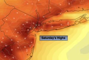
Saturday:
Early morning clouds East, otherwise mostly sunny and warm. Much less humid. Highs in the lower to mid 80s.
Sunday:
Sunny and cooler. Highs around 70º.
Monday:
Partly sunny. Cool. Highs in the upper 60s.
Tuesday:
Partly sunny. Highs in the lower 70s.
Wednesday:
Partly sunny. Warmer. Highs around 80º.