Synopsis:
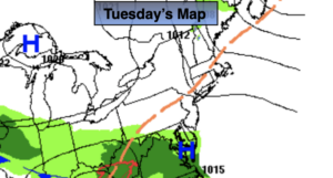
Today will be partly sunny with readings several degrees below the average high of 68º. High pressure will dominate the Northeast.
Clouds will move in tonight as the next system to the South moves North.
On Wednesday a weak low will move from North Carolina to a position up and off our coast. Showers are likely by afternoon.
Thursday will be tranquil and bright as we’ll be in between systems.
On Friday a developing low on a front moving in from the West will result in cloudy skies with rain developing by afternoon.
Mother’s Day weekend will be Fall-like. Saturday will be windy and very cold for this time of the year. Temperatures will be hard pressed to reach 50º. The gusty winds will add a bite with feels-like readings only in the 40s. Spotty showers are possible. Well inland, a few May flakes may fly (you heard me)!
Mother’s Day will be more tranquil but it will still be unseasonably chilly with a mix of sun and clouds. I’m only the messenger mom.
Stay Tuned.
Keep it here for a no nonsense, no hype forecast.
Today:
Partly sunny. Highs in the lower 60s. Northwest winds at 8-12mph.
Tonight:
Increasing clouds. Lows in the mid 40s in the City, the 30s inland. Northeast winds at 5mph.
Wednesday:
Mostly cloudy. Chance of afternoon showers. Highs in the mid 50s.
Thursday:
Partly sunny. Highs in the lower 60s.
Friday:
Mostly cloudy. Rain by afternoon. Highs in the upper 50s.
Saturday:
Mostly cloudy, windy and cold. Spotty showers. A few flurries inland. Highs in the 40s to around 50º.