Synopsis:
High pressure will move in from the Great Lakes today providing the region with plenty of sunshine and seasonal temperatures.
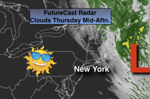
An ocean storm (map above) will begin retrograde to the coast. This will increase our clouds. Bands of light rain will work in from the ocean later tonight and Friday. There will be dry times on Friday, but it will be quite raw with a gusty North wind.
The first weekend of April will be pleasant as a ridge of high pressure develops over the Mid-Atlantic. The sun should rule with readings getting at or above average (temperatures should be in the mid 50s).
Stay Tuned.
Keep it here for a no nonsense, no hype forecast.
Today:
Mostly sunny. Highs in the mid 50s. Northwest winds at 15-25mph.
Tonight:
Increasing clouds with areas of light rain late. Breezy. Lows 40º-45º. North winds at 15-25mph with higher gusts at the coast.
Friday:
Cloudy with on and off rain. Breezy. Highs in the lower 50s.
Saturday:
Partly sunny. Highs in the upper 50s.
Sunday:
Mostly sunny. Highs in the lower 60s.
Monday:
Partly sunny. Mild. Highs in the mid 60s.
***Please take “social distancing” seriously during this time. We will get through this.****