Synopsis:
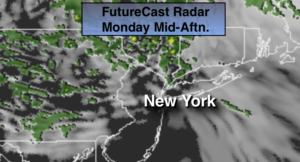
Areas of fog and clouds will greet us this morning. The grey will finally give way to a few peeks of sun. The atmosphere will finally dry out some by midday. An upper low will move toward the Northeast during the afternoon. This feature will spark scattered showers during the afternoon.
The chance of showers will continue tonight.
Spotty showers Tuesday morning, otherwise skies will be mostly cloudy and it will be chilly. The upper low will swing off the coast and bring down below average readings.
As we turn the page to April on Wednesday, a storm will be well to our South. All of the models have this system not affecting the area so at this time only the clouds from the storm look to push this far to the North.
High pressure will move in from the Great Lakes by the end of the week with increasing sunshine and seasonal temperatures.
Stay Tuned.
Keep it here for a no nonsense, no hype forecast.
Today:
Early clouds and fog should give way to partial sunshine for a few hours. Clouds once again dominate during the afternoon. Spotty showers are possible. Highs in the upper 50s. West/Northwest winds at 8-12mph.
Tonight:
Mostly cloudy with scattered showers. Lows in the upper 30 to lower 40s. Northeast winds less than 5-10mph.
Tuesday:
Morning showers otherwise more clouds and sun. Highs around 50º.
Wednesday:
Mostly cloudy. Highs in the lower 50s.
Thursday:
Mostly sunny. Highs in the upper 50s.
Friday:
Mostly sunny. Highs in the upper 50s.
***Please take “social distancing” seriously during this time. We will get through this.****