Synopsis:
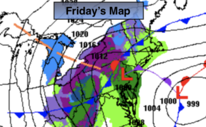
Any morning sun will give way to clouds today. A storm will be developing off the coast and a clipper moving in from the North and West. The ocean storm will not connect with the clipper until it’s well to the East of the City. This scenario will result in rain showers this afternoon possibly going over to snow showers by evening and at night. IF, and only if there is enough cold air and heavier precipitation, a coating maybe possible where the band sets up. This will be isolated and a low potential. The best chance for this to occur is over Western and Central NJ and Eastern Long Island with the latest computer models. This will not be a big deal.
Saturday will be windy and colder under a mix of sun and clouds with a strong Northwest wind behind the storm.
Sunday will be Spring-like again with readings well into the 50s as high pressure moves to the East coast and a Southwesterly flow develops.
Well above average temperatures will continue into early next week.
Stay Tuned.
Keep it here for a no nonsense, no hype forecast.
Today:
Early morning sun will give way to mostly cloudy skies. Scattered showers are possible during the afternoon. Snow showers may mix in by late day. Highs in the mid to upper 40s. East to Northeast winds at 8-12mph.
Tonight:
Rain or snow showers South and East otherwise becoming partly cloudy. Lows freezing throughout. Northeast winds becoming North and increasing to 15-25mph.
Saturday:
Mostly sunny, windy and chilly. Highs in the mid 40s.
Sunday:
Sunny. Much milder. Highs in the mid to upper 50s.
Monday:
Sunny. Warm. Highs in the mid 60s.
Tuesday:
Sun giving way to clouds. Afternoon showers likely. Highs in the lower 60s.