Synopsis:
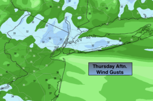
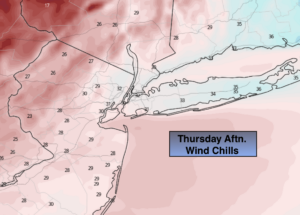
We’ll dry out today as the sun returns along with a strong Northwest wind. Wind gusts up to 45mph will be common. Temperatures will actually fall today into the 30s inland to near 40º at the coast. Wind chills will be near freezing along the coast, the 20s inland. It’ll be a shock heading outdoors.
The chill will stick around for the last few days of February. March is Sunday and it will come in like a lamb. Low pressure over Eastern Canada and high pressure over the South will cause the winds to be busy into the weekend. A mix of sun and clouds is expected.
Late day showers are possible on Monday with readings once again getting above average. The average high is 44º.
Spring-like readings will once again be with us for midweek next week.
Stay Tuned.
Keep it here for a no nonsense, no hype forecast.
Today:
Partly sunny and windy. Highs in the mid 40s. Temperatures will fall during the afternoon. West winds at 15-30mph with gusts to 45mph.
Tonight:
Partly cloudy and cold. Winds will diminish some. Lows in the mid to upper 20s along the urban corridor, to around 20º inland. West winds at 15-30mph.
Friday:
Partly sunny. Highs around 40º.
Saturday:
Partly sunny. Colder. Highs in the upper 30s.
Sunday:
Partly sunny. Highs around 40º.
Monday:
Mostly cloudy with afternoon showers. Highs in the mid 40s.