Synopsis:
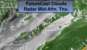
A low will move from West Virginia tonight to Southern New England on Thursday. The track will be to our West. This will result in another round rain and mild temperatures for tonight and the first part of Thursday. Rain will develop later this evening. Well inland, snow and sleet may fall for an hour or so but here too the warm air will win out. This system is a quick mover. The rain will end toward midday on Thursday and some sun is expected in the afternoon. It will be mild.
Behind the low, cold air will arrive Friday under mostly sunny skies. A semi-Arctic push of air will move in from the North. Friday night will be the coldest it’s been in some time. The weekend will be sunny. Saturday will be cold with readings hard pressed to get to freezing. Sunday will be more tolerable with temperatures rebounding into the 40s.
Presidents’ Day will be mostly sunny and mild.
Stay Tuned.
Keep it here for a no nonsense, no hype forecast.
Tonight:
Rain developing late in the evening. An hour or so of snow and sleet well inland will quickly turn to rain. Lows around 40º in the City, the 30s inland. Southwest winds becoming East at 5-10mph.
Thursday:
On and off rain through midday. Clouds may break for some afternoon sun. Mild. Highs around 50º. West to Northwest winds at 8-12mph.
Friday:
Mostly sunny, colder. Highs in the lower 30s.
Saturday:
Sunny. Highs in the 20s to around 30º.
Sunday:
Partly sunny. Milder. Highs in the lower to mid 40s.
Presidents’ Day:
Mostly sunny. Mild. Highs in the upper 40s.