Synopsis:
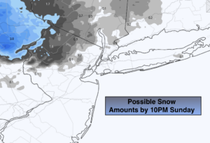
There will be areas of rain and wet snow (North & West) into this evening. A coating of snow is possible on colder surfaces N&W. A warm front moving in from the West is the cause of the precipitation. Skies will become partly cloudy overnight.
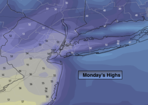
A warmup is on the way for the beginning of the workweek as strong high pressure settles off the Southeast coast. This will result in Spring like readings Monday and Tuesday. Spotty showers are possible on Tuesday and Wednesday as a cold front approaches. Wednesday will be cooler as the wind turns to the North.
It will get quite active late week as a front stalls along the East coast and waves of low pressure ride up the coast. It maybe cold enough as high pressure noses in from Eastern Canada on Thursday for a potential mix of snow, freezing rain, sleet and or rain. The frozen precipitation is more likely North and West with coastal areas remaining primarily rain.
On Friday as the second wave of low pressure moves North and the cold high moves into the Northern Atlantic. It will be much milder. Rain is likely. The rain cold be heavy at times. Please check back with JMW for the latest very latest.
Stay Tuned.
Keep it here for a no nonsense, no hype forecast.
Tonight:
Scattered areas of rain and wet snow (North & West). A coating of snow is possible on colder surfaces well inland. Lows in the upper 30s in the City, closer to 30º inland. West to Northwest winds at 5-10mph.
Monday:
Partly sunny and much milder. Highs in the mid 50s. West winds at 5-10mph.
Tuesday:
Mostly cloudy. Mild. Spotty showers are possible. Highs in the mid 50s.
Wednesday:
Morning showers will give way to a sunny afternoon. Cooler. Highs in the lower 40s.
Thursday:
Colder. The potential for snow, freezing rain, sleet & rain inland. Mainly rain at the coast. Highs in the 30s.
Friday:
Warmer. Rain likely. Highs in the lower 50s.