Synopsis:
Extensive high pressure will dominate the Mid-Atlantic and Northeast through the end of the week. Plenty of sunshine and readings at or above seasonal averages are expected through the Friday the 31st.
A storm will develop off the East coast on Saturday. The storm will be far enough offshore to spare the region significant rain or snow. Scattered rain or snow showers are possible if the precipitation shield grazes the coast. Not a big deal. Sunday- Ground Hog Day, will be breezy with a mix of sun and clouds.
A warmup is expected next week. Readings will reach the 50s! Our dud of a Winter continues.
Stay Tuned.
Keep it here for a no nonsense, no hype forecast.
Tonight:
Clear and colder. Lows in the upper 20s in the City, the teens and 20s inland. North winds at 5-10mph.
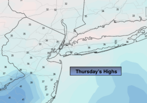
Thursday:
Sunny. Highs in the mid 30s. Northeast to East winds at 5mph.
Friday:
Sun and clouds. Highs in the lower 40s.
Saturday:
Mostly cloudy. A chance of snow or rain showers. Highs in the lower 40s.
Sunday:
Partly sunny. Highs in the lower 40s.
Monday:
Partly sunny and much milder. Highs in the lower 50s.