Synopsis:
Today will be windy and colder behind departing storm in Eastern Canada. A mix of sun and clouds is expected. Scattered snow squalls are possible by late morning into the afternoon. Any squall can reduce visibility to near zero and put a coating of snow on the ground within minutes. Please use caution and be aware of the rapidly changing weather conditions. Not all areas will receive a squall. Winds will gust between 40-50mph. A small dog alert has been posted.

Tonight will be clear, windy and much colder than it has been. All areas will be well below freezing. Winds will diminish late.
Thursday will be bright and seasonal as strong high pressure moves overhead. The average high temperatures are in the upper 30s.
On Friday the high pressure system will move off the coast. A return Southwesterly flow will cause readings to pop into the 50s. In fact, readings will reach the Spring-like 60s both Saturday and Sunday. Spotty showers are possible on Saturday. Steadier rain is likely either Saturday night or Sunday morning with an approaching cool front.
It will be some time until we experience an Arctic blast or a decent snow event. The weather pattern is horrible for Winter conditions. Sorry snow lovers.
Stay Tuned.
Keep it here for a no hype, no nonsense forecast.
Today:
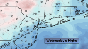
Sun and clouds. Scattered late morning and afternoon snow squalls, windy and cold. Highs in the upper 30s. West to Northwest winds at 15-30mph with gusts to 45mph.
Tonight:
Clear, windy and cold. Lows in the lower 20s in the City, the teens inland. Northwest wind 15-30mph with gusts to 40mph early. The winds will diminish late.
Thursday:
Sunny and seasonal. Highs in the mid to upper 30s.
Friday:
Sun and clouds. Much milder. Highs in the lower 50s.
Saturday:
Mostly cloudy and warm with spotty showers. Highs in the lower 60s.
Sunday:
Mostly cloudy and warm with a period of rain likely in the morning. Highs in the lower 60s.