Synopsis:.
High pressure offshore will bring in moisture from the East resulting in more clouds today. Spotty showers are possible later this afternoon and tonight. Many areas will remain dry.
A disturbance will move from the Great Lakes into Northern New England on Friday. Once again clouds will dominate.
The weekend will start off bright and mild as high pressure moves in from the Ohio Valley. On Sunday, a storm will move well West of the area. This is a warm storm track. Morning sun will give way to thickening clouds. Showers should move in by late day. Rain is likely Sunday night into Monday.
Readings throughout the next several days will be well above the average high of the upper 30s. All of the Arctic air is banked up in Canada.
Stay Tuned.
Keep it here for a no hype, no nonsense forecast.
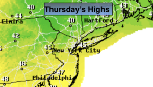
Today:
More clouds than sun. Spotty late day showers are possible. Highs in the mid 40s. Northeast winds at 5-10mph.
Tonight:
Mostly cloudy. Spotty showers are possible. Lows around 40º in the City, the 30s inland. East to Southeast wind at 5mph.
Friday:
Clouds, some sun. Mild. Highs around 50º.
Saturday:
Mostly sunny. Highs near 50º.
Sunday:
Morning sun will give way to clouds. Showers are likely later in the day. Mild. Highs in the lower 50s.
Monday:
Periods of rain. Highs in the mid 50s.