Synopsis:.
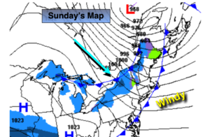
Today will be the better half of the weekend despite the gusty wind. A mix of clouds and sun is expected as low pressure moves into Eastern Canada and high pressure sits over the Ohio Valley.
It’ll be partly cloudy and cold tonight. Lows throughout will be below freezing.
For Monday an arc of moisture will stream ahead of a developing low in the Tennessee Valley. The potential continues for light snow or snow showers to break out Monday afternoon for most areas. South of the City a mix of snow, sleet and rain is likely. There is just enough cold air for a possible accumulation of snow by Monday Night. It doesn’t look like much at this time. The best chance of this is North and West of the City. The warm air should win the battle and the frozen precipitation will go over to rain along the coast Monday night. Inland mixed precipitation will continue and an accumulation of sleet and ice is quite possible.
The low will move off the coast on Tuesday. Sleet and freezing rain just inland and rain along the coast will continue. The precipitation will taper off during the afternoon.
Wednesday we’ll dry out under a mix of clouds and sun. It will turn dramatically colder during the afternoon as Arctic air moves in.
Cold sunshine is expected for Thursday.
There has been chatter about a weekend storm. It’s way too early to even talk about the potential.
Stay Tuned.
Keep it here for a no hype, no nonsense forecast.
Today:
Partly sunny, windy. Highs in the mid to upper 40s. West winds at 15-25mph with gusts to 35mph.
Tonight:
Becoming partly cloudy. Diminishing winds. Lows around 30º in the City, the 20s inland. West wind decreasing to 5-10mph.
Monday:
Cloudy and cold with light snow developing during the afternoon. A mix of snow, sleet and rain to the South of the City. Highs in the mid to upper 30s.
Tuesday:
Rain along the coast. Sleet and freezing rain inland tapering off during the afternoon. Highs in the 40s along the coast, the upper 30s inland.
Wednesday:
Partly sunny, windy and turning colder during the afternoon. Highs around 40º in the morning with readings dropping to near freezing by late day.
Thursday:
Sunny and cold. Highs around freezing.